Typhoon Hinnamnor 2022 Cloud Map East China Sea 3D Render Color - Stockfoto
3D Render of a Topographic Map of the Philippine Sea with the clouds from September 04, 2022. Typhoon Hinnamnor northeast of Taiwan.All source data is in the public domain.Cloud texture: Global Imagery Browse Services (GIBS) courtesy of NASA, HIMAWARI-8 data courtesy of NOAA.https://www.earthdata.nasa.gov/eosdis/science-system-description/eosdis-components/gibsColor texture: Made with Natural Earth.http://www.naturalearthdata.com/downloads/10m-raster-data/10m-cross-blend-hypso/Relief texture: GMTED 2010 data courtesy of USGS. URL of source image:https://topotools.cr.usgs.gov/gmted_viewer/viewer.htmWater texture: SRTM Water Body SWDB: https://dds.cr.usgs.gov/srtm/version2_1/SWBD/

Bestel uw ingelijste foto direct en bekijk de diverse opties op Photos.com.
LICENTIE KOPEN
Alle royalty free licenties bieden wereldwijde gebruiksrechten en uitgebreide bescherming. Daarnaast zijn er eenvoudige tarieven met volumekortingen beschikbaar.
€ 335,00
EUR
Getty ImagesTyphoon Hinnamnor 2022 Cloud Map East China Sea 3d Render Color, Stockfoto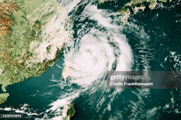 Download premium, authentieke Typhoon Hinnamnor 2022 Cloud Map East China Sea 3D Render Color stockfoto's van Getty Images. Verken vergelijkbare stockfoto's met hoge resolutie in onze uitgebreide visuele catalogus.Product #:1428954895
Download premium, authentieke Typhoon Hinnamnor 2022 Cloud Map East China Sea 3D Render Color stockfoto's van Getty Images. Verken vergelijkbare stockfoto's met hoge resolutie in onze uitgebreide visuele catalogus.Product #:1428954895€335€50
Getty Images
In stockGEGEVENS
Credits:
Creatief nr.:
1428954895
Soort licentie:
Collectie:
E+
Max. bestandsgrootte:
5800 x 3860 px (49,11 x 32,68 cm) - 300 dpi - 13 MB
Datum van uploaden:
Locatie:
Taiwan
Release-informatie:
Property release
Categorieën:
- Tyfoon,
- Taiwan,
- Klimaatverandering,
- Weer,
- Natuurramp,
- Ongelukken en rampen,
- China - Oost-Azië,
- Luchtfoto,
- Kaart,
- Wolk,
- Grote oceaan,
- Milieu,
- Satellietfoto,
- Vlak erboven,
- Wind,
- Wolkenlandschap,
- 2022,
- Cartografie,
- Computergrafieken,
- Digitaal beeld,
- Digitaal samengesteld beeld,
- Driedimensionaal,
- Eiland,
- Extreem weer,
- Fysische geografie,
- Horizontaal,
- Illustratie,
- Kleurenfoto,
- Kyushu,
- Landschap - Buiten de steden gelegen gebied,
- Oost-Chinese Zee,
- Philippine Sea,
- Ryukyu Eilanden,
- Sociale kwesties,
- Topografie,
- Topografische kaart,
- Tropische storm,
- Zonder mensen,